Twilight Route

See the light you'll drive in.

Twilight Route lays a US road trip against the sun: when it sets and rises along your way, when it sits low in your eyes, and how much riskier the miles get after dark. Then it helps you pick a better time to leave.

Open the live demo Five preset drives you can re-time as you like. No sign-up; it runs in your browser.

Every stage of dusk and dawn, on your route.

Golden hour and sunset, then the three stages of twilight as the sky dims: civil (the last useful daylight), nautical (the horizon fades) and astronomical (the last glow), and then night. Each is worked out for every mile at the moment you'd drive it, on that place's own clock, and drawn on the road.

Leaving Los Angeles at 6 PM, all of dusk is over within the first 127 miles: 18 minutes of golden hour, then 23, 28 and 27 minutes of civil, nautical and astronomical twilight.
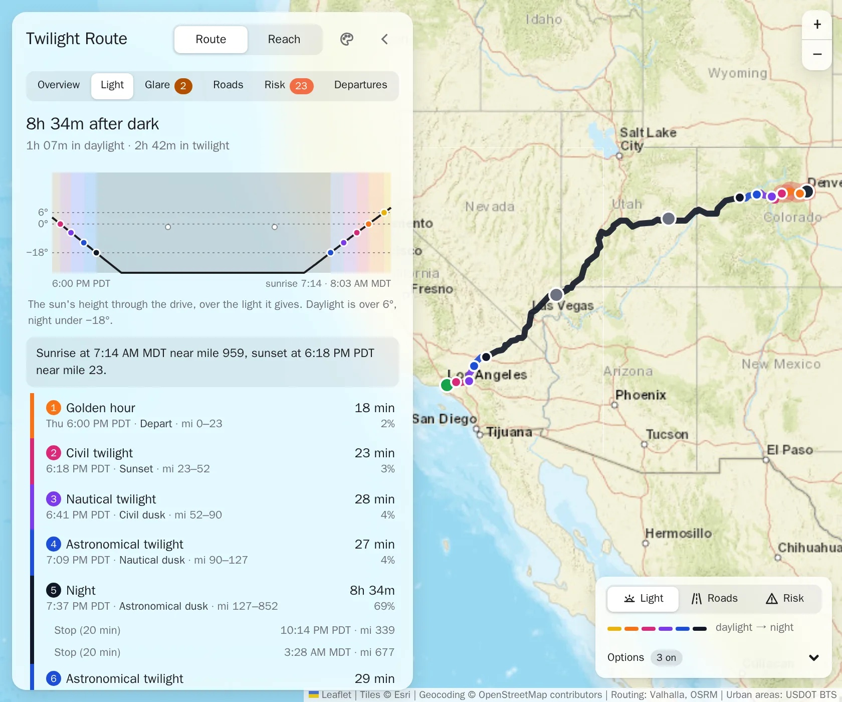
The Light tab for Los Angeles to Denver at 6 PM: 8h 34m after dark, a chart of the sun's height through the drive, and its light periods from golden hour (mile 0 to 23) through civil, nautical and astronomical twilight to night from mile 127, beside the route on the map.
Los Angeles to Denver at 6 PM, the Light tab.

Know when the sun is in your eyes.

A low sun close to straight ahead is the glare that hides brake lights and lane lines. Twilight Route finds every stretch where the sun is under 15° and within 25° of your heading, highlights it on the map, and shows where the sun sits in the view ahead.

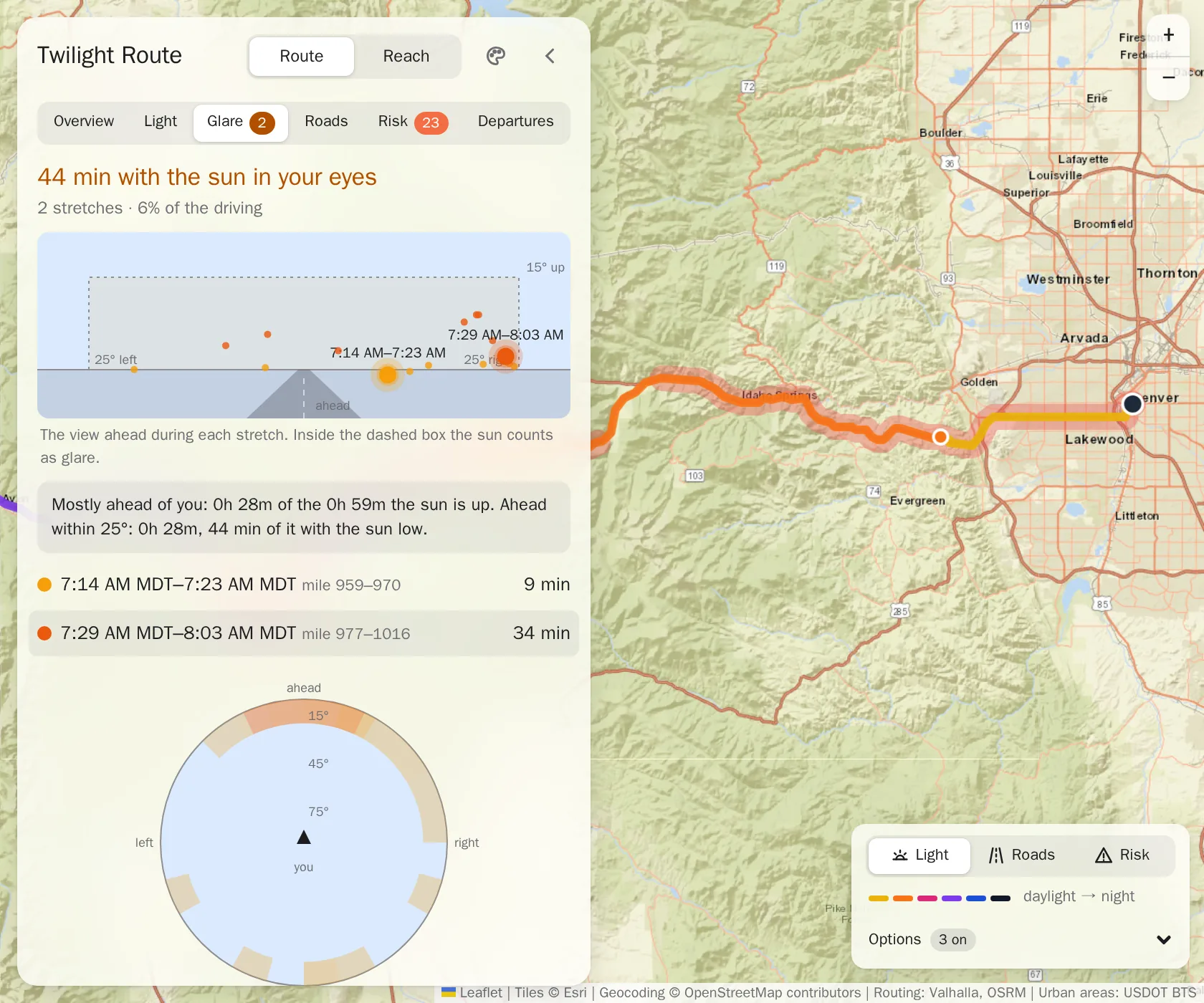
Even this overnight drive has glare: 44 minutes in two stretches. The longest is the last 34 minutes into Denver, from 7:29 AM, straight into the rising sun.

The Glare tab for Los Angeles to Denver at 6 PM: 44 minutes with the sun in your eyes in two stretches, the view ahead with the low morning sun inside the glare box, the longest stretch from 7:29 to 8:03 AM at miles 977 to 1016, and the map highlighting I-70 from Idaho Springs into Denver.
Los Angeles to Denver at 6 PM, the Glare tab.

See what the dark adds to the risk.

Each mile gets a fatality rate for its setting (rural or urban), the kind of road, and whether you drive it in daylight, civil twilight or after civil dusk. The Risk tab adds them up as you go, in micromorts: one-in-a-million chances of dying. For scale, US driving as a whole averages about 1.3 per 100 miles.

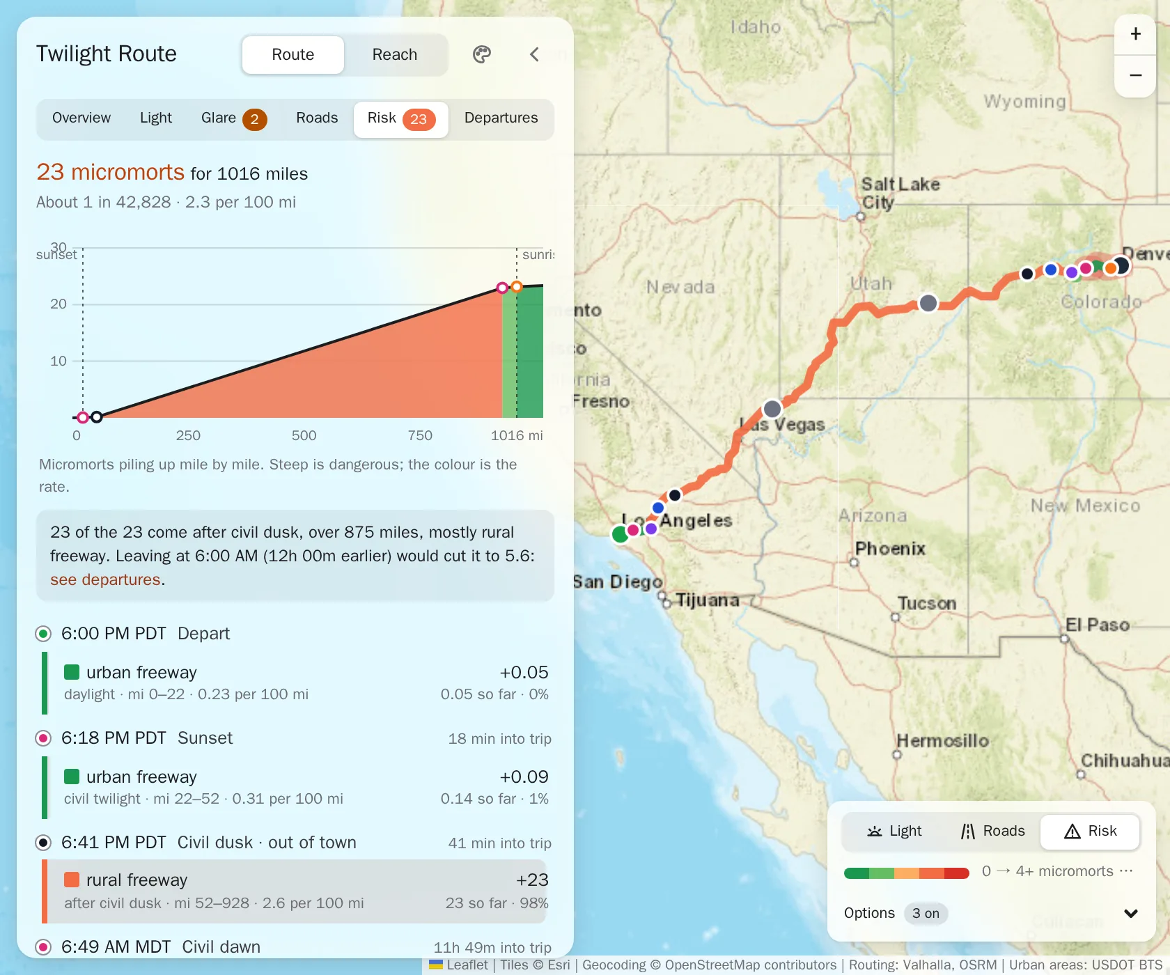
This drive comes to 23 micromorts over 1,016 miles, about 1 in 43,000: 2.3 per 100 miles, nearly twice the US average. Almost all of it comes after civil dusk, on 875 miles of rural freeway.

The Risk tab for Los Angeles to Denver at 6 PM: 23 micromorts for 1016 miles, about 1 in 42,828, a chart of the risk climbing steeply from civil dusk to sunrise, the note that 23 of the 23 come after civil dusk over 875 miles of rural freeway, and the route on the map coloured by its risk.
Los Angeles to Denver at 6 PM, the Risk tab.

Find a better hour to leave.

The same drive, leaving at every hour of the day, side by side: when you'd arrive, how long you'd spend in twilight and in night, and the risk. Pick a row and the whole plan moves to that time.

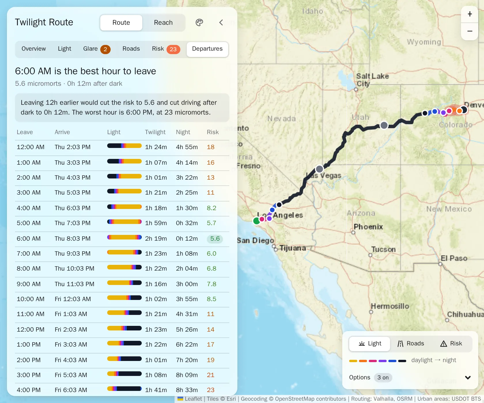
For this drive, any start from 5 to 9 AM keeps the risk under 8 micromorts, while every start from 3 to 7 PM comes out at 21 or more.

The Departures tab for Los Angeles to Denver: 6:00 AM is the best hour to leave, at 5.6 micromorts with 0h 12m after dark, the worst is 6:00 PM at 23, and a table of every departure hour with its arrival, light, twilight, night and risk.
Los Angeles to Denver at 6 PM, the Departures tab.

Everywhere you can get before dark.

Reach turns it around: from a start and a time, every road you could drive to, coloured by the light you'd arrive in there. Ask for a number of hours, or for everywhere you can get before full dark falls, and change the hour with one tap.

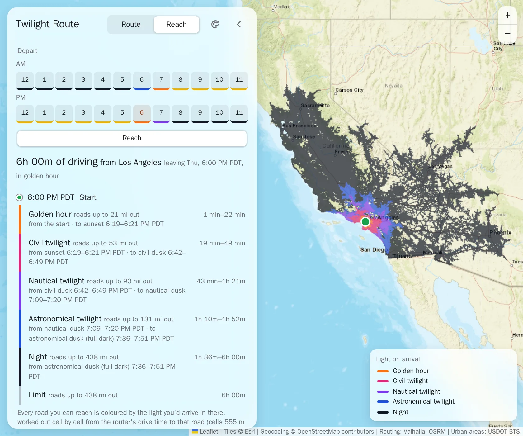
From Los Angeles at 6 PM, six hours of driving: golden hour reaches 21 miles out and twilight 131. Every road beyond that, out to 438 miles, is reached in full night.

Reach from Los Angeles at 6 PM with six hours of driving: the departure hours, the bands from golden hour (roads up to 21 miles out) through the three twilights (up to 131 miles) to night (up to 438 miles), and the road network from the coast to Nevada and Arizona, coloured from twilight near Los Angeles to night beyond.
Los Angeles at 6 PM, six hours of Reach.

Real roads, real sun, real numbers.

Roads and timing
Routes on OpenStreetMap, from a self-hosted Valhalla router, timed at each road's posted limit (with your own allowance over it on freeways).
The sun, place by place
Sun height and direction for every point along the drive at the time you'd be there, in that place's time zone.
The risk
US traffic deaths from NHTSA's FARS records, 2021 to 2023, over FHWA travel, split by setting, road type and light.

Also in Classic.

One switch turns the whole app into a mid-90s desktop: window chrome, a recoloured street map, and the same light underneath.

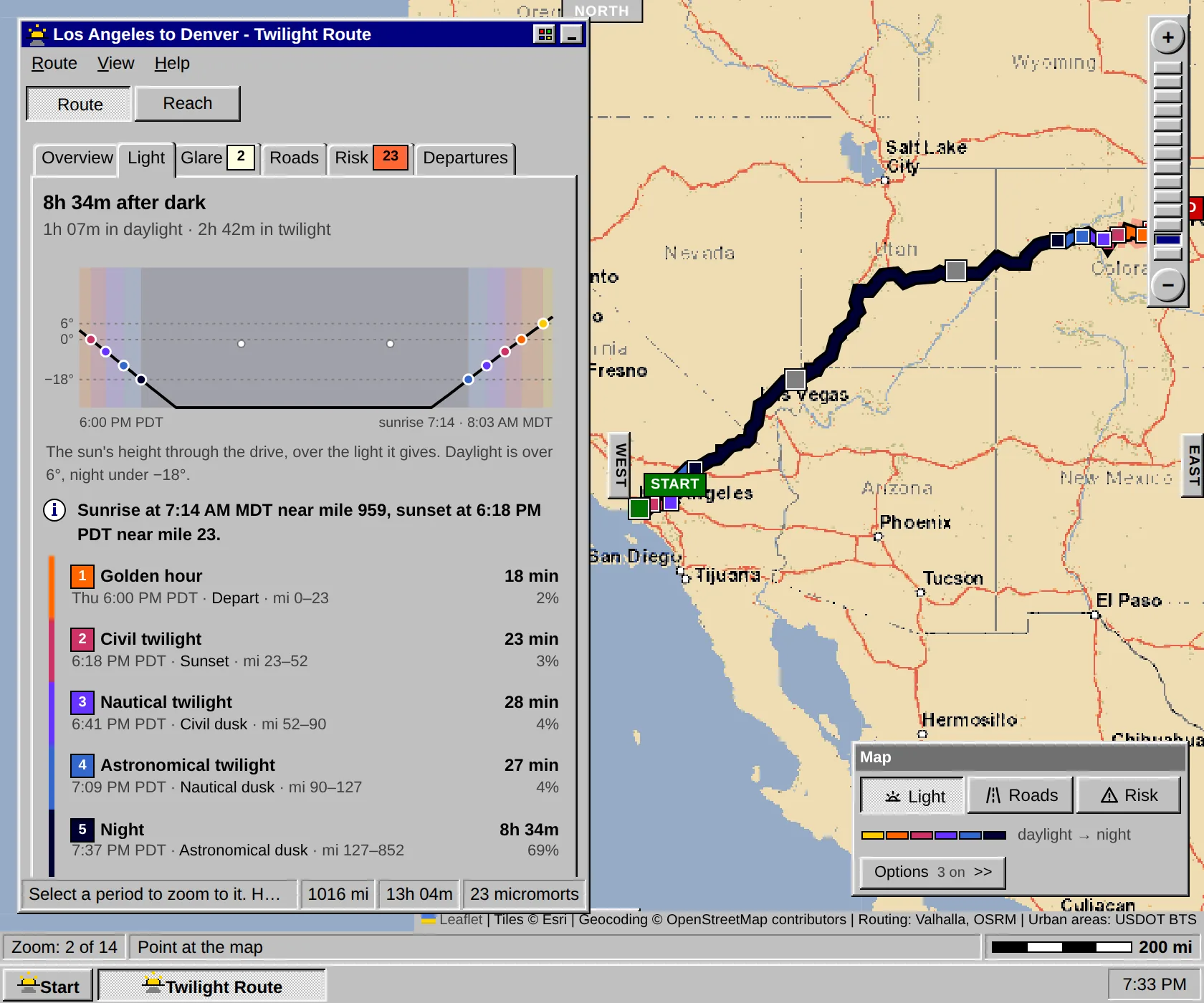
Twilight Route in the Classic theme: Los Angeles to Denver at 6 PM in a 1990s desktop window, on the Light tab with the sun's height and the light periods, over a retro-styled street map.
Los Angeles to Denver at 6 PM, the Light tab in the Classic theme.

Try it on a real drive.

Pick one of five long drives, then move the departure around and watch the light, the glare and the risk follow.

Open the live demo